

Sierra backpacking season at low elevation should have started in mid-May, but the unseasonably cold and wet May in California this year pushed that back. Finally near the end of the month we saw a window with reasonable weather and took off for the Domeland Wilderness. This wilderness area sits in the southern Sequoia National Forest south of Kennedy Meadows. The elevations are low enough to allow entry much earlier than the higher Sierra to the north. And the rock formations in the area give it a considerable "Yosemite" look and feel. A significant amount of this wilderness area burned in the 2000 Manter fire. Additionally, there are very few visitors and no trail maintenance for years, so we knew going in that we would have to be prepared to navigate off trail. That turned out to be the case for about half of our miles.
We connected some map trails to create a 25'ish mile loop in the wilderness but needed to get there first. Our first attempt was over Bakeoven Pass cross-country from the Sherman Pass road. We were thwarted quickly by several inches of overnight snow and an early crossing of Fish Creek - normally a tiny stream, but this year a raging torrent of water. After about a mile and a half round trip we were back to the car.


We knew another approach to Domeland was southbound on the PCT from Kennedy Meadows, but this would require us to cross the South Fork Kern River. The Kern was a boiling torrent so we quickly abandoned that thought. But if we stayed on the west side of the Kern and took off cross-country to the south, we could connect to our loop trail. Off we went.
The terrain started out friendly through the sagebrush of south Kennedy Meadows. Quickly enough the mountains jumped up and pushed us toward the river. With some ups and downs and rock scrambling we made the 6 miles out to connect with our loop.

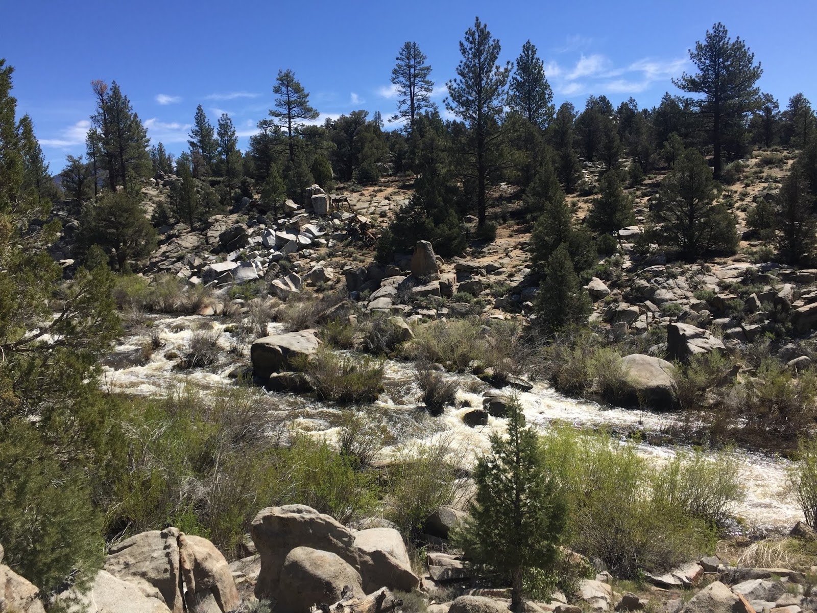 |
| South Fork Kern River |


Day two broke to beautiful blue skies that wouldn't last. We continued west for a mile or so reaching Woodpecker Meadow and the southbound turn on our loop. In a short distance we were at Trout Creek. This is another stream that should have been an easy crossing, but not this year. It took us a while to find a relatively safe crossing that tested the skills we developed a few years ago on the PCT. There's big water in the streams this year...


As we pushed south into high country the clouds chased us down from behind. By early afternoon it was raining off and on, and the once easily followed trail disappeared into down trees and an overgrown tangle of brush sprouted by the Manter fire. Scratched and bleeding we trudged to the highest point on our route at 8,100 feet and an eastbound turn on the loop.


 |
| There was a blood price to pay on this trip. |

The trail was decent again for a while and the scenery spectacular. A few miles down we again lost the trail in a jungle of brush. Good views, the dodgy weather, and a close by water source was all the persuasion we needed to pitch the tent for the night.


We awoke to mostly blue skies on day three, but I could tell by the thin clouds that it wouldn't last. We had no trail but knew by gps where we were supposed to go so headed off down the hill. Weaving up and down and in and out of various drainages we made it to the amazingly wide open and sandy Tibbets creek. We followed this stream down for a couple miles before striking off to northeast for the confluence of Trout Creek and the Kern in Rockhouse Basin. Just below an old beaver dam we found a safe crossing for Trout Creek. We looked longingly across the Kern at the cruiser trail of the PCT that would make quick work of our return, but the water was easily neck deep in much of the river. Oh well... Fish Creek was only a mile away and we had to cross that thing again. I had waypointed the log crossing so we struck out directly for it. As we approached the stream the rain started to fall, this time seriously. We scurried across the log and threw up the tent in the first flat spot we found. An hour later the downpour abated but the skies looked menacing. With only 6 cross-country miles left to our car, a hot shower, and a soft bed we beat feet. We retraced our route from day 1 in intermittent rain with car wash bushes soaking our legs and feet. Rock scrambling in the rain wasn't a lot of fun, and I didn't come out of the experience unscathed. So it is with hiking...


We made it back to the car successfully completing our loop of Domeland Wilderness. It's a neat area with outstanding scenery that will get us back one day for more exploration. Hopefully next time with better weather and easier stream crossings.
Birding on our trip was outstanding. We easily exceeded our pre-trip guesses of total species count with an amazing 66 species.
Cinnamon Teal - Spatula cyanoptera
Mallard - Anas platyrhynchos
Mountain Quail - Oreortyx pictus
California Quail - Callipepla californica
Mourning Dove - Zenaida macroura
Common Poorwill - Phalaenoptilus nuttallii
White-throated Swift - Aeronautes saxatalis
Anna's Hummingbird - Calypte anna
Costa's Hummingbird - Calypte costae
Killdeer - Charadrius vociferus
Spotted Sandpiper - Actitis macularius
Red-tailed Hawk - Buteo jamaicensis
Great Horned Owl - Bubo virginianus
Red-breasted Sapsucker - Sphyrapicus ruber
Hairy Woodpecker - Dryobates villosus
White-headed Woodpecker - Dryobates albolarvatus
Northern Flicker - Colaptes auratus
American Kestrel - Falco sparverius
Olive-sided Flycatcher - Contopus cooperi
Western Wood-Pewee - Contopus sordidulus
Gray Flycatcher - Empidonax wrightii
Dusky Flycatcher - Empidonax oberholseri
Ash-throated Flycatcher - Myiarchus cinerascens
Plumbeous Vireo - Vireo plumbeus
Warbling Vireo - Vireo gilvus
Pinyon Jay - Gymnorhinus cyanocephalus
Steller's Jay - Cyanocitta stelleri
California Scrub-Jay - Aphelocoma californica
Clark's Nutcracker - Nucifraga columbiana
Common Raven - Corvus corax
Violet-green Swallow - Tachycineta thalassina
Mountain Chickadee - Poecile gambeli
Bushtit - Psaltriparus minimus
White-breasted Nuthatch - Sitta carolinensis
Pygmy Nuthatch - Sitta pygmaea
Rock Wren - Salpinctes obsoletus
Bewick's Wren - Thryomanes bewickii
Blue-gray Gnatcatcher - Polioptila caerulea
Wrentit - Chamaea fasciata
Western Bluebird - Sialia mexicana
Townsend's Solitaire - Myadestes townsendi
American Robin - Turdus migratorius
California Thrasher - Toxostoma redivivum
House Finch - Haemorhous mexicanus
Cassin's Finch - Haemorhous cassinii
Chipping Sparrow - Spizella passerina
Brewer's Sparrow - Spizella breweri
Lark Sparrow - Chondestes grammacus
Fox Sparrow - Passerella iliaca
Dark-eyed Junco - Junco hyemalis
Song Sparrow - Melospiza melodia
Green-tailed Towhee - Pipilo chlorurus
Spotted Towhee - Pipilo maculatus
Red-winged Blackbird - Agelaius phoeniceus
Brown-headed Cowbird - Molothrus ater
Brewer's Blackbird - Euphagus cyanocephalus
Orange-crowned Warbler - Oreothlypis celata
MacGillivray's Warbler - Geothlypis tolmiei
Yellow Warbler - Setophaga petechia
Yellow-rumped Warbler - Setophaga coronata
Black-throated Gray Warbler - Setophaga nigrescens
Townsend's Warbler - Setophaga townsendi
Western Tanager - Piranga ludoviciana
Black-headed Grosbeak - Pheucticus melanocephalus
Lazuli Bunting - Passerina amoena
Another great blog entry. I must start using the Gaia GPS app. What a great resouce you provide by just linking to that track.
ReplyDeleteYour great commentary sure helps me to understand what you are encountering. Great views of the Domes and the dramatic weather photos.
ReplyDeleteThank you for sharing.