Sunday, April 26, 2015

Olancha Pass

The Owens Lake Bird Festival Saturday was a big hit.  Everyone enjoyed themselves, at least until the late afternoon field trips which were seriously hampered by a wicked north wind.  Still, for a first-time event, we thought it was well done.  They will make changes for next year and it will be even better.

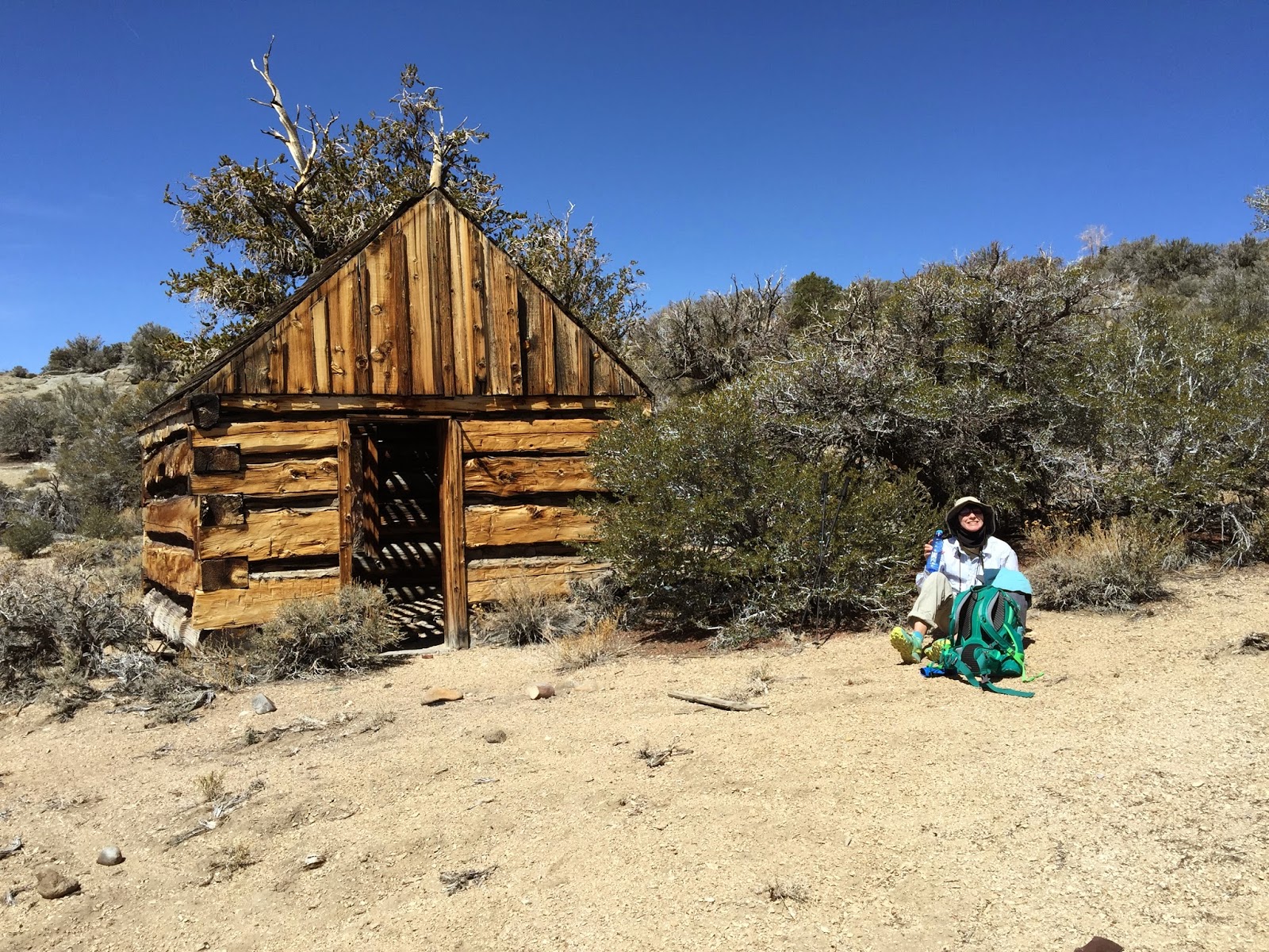
Since we stayed in Lone Pine Saturday evening, we decided to do some Sierra hiking on the way home this morning.  A trail that's been on our radar was Olancha Pass.  This trail leaves from the Sage Flats road end at an elevation of 5,600 feet and climbs to 9,200 feet at the pass in about 6 miles. The trail was in remarkably good shape considering how little attention it gets, and parts of it are sometimes used to move cattle into and out of the high country.

The trailhead is in a large oak grove that we didn't take the time to bird much, but did hear Oak Titmouse almost immediately after starting out.  A couple of Ruby-crowned Kinglets were also making themselves heard.  Leaving the oak grove, the trail hugs the side of a deep canyon for several miles, quickly gaining elevation on a good trail.  Two Western Bluebirds were easy to see a short distance up the trail.
The trail low down


The birding really got interesting when Susan almost literally kicked up two Common Poorwills that were roosting on the trail edge at about 7,400 feet elevation.  Both flushed out from under her feet and landed a short distance away for excellent viewing.  Needless to say it was quite a surprise.


"Cow Driveway"


At one point the hiking/equestrian trail diverges from the "cow driveway."  That was certainly not a problem for us as the regular trail was quite pleasant and the "driveway" looked pretty torn up as would be expected.


Canyon with Oaks and Pines
In such a steep canyon, it is fascinating to watch the habitat zones change quickly, with much vegetation mixing as we moved along.  The oaks reached nearly 8,000 feet in elevation and were side-by-side with the first fir and pine trees.  Sooty Grouse were regular as soon as we reached the large Jeffery Pines.  We counted 9 "booming" males in the last few miles of trail to the pass. This location must be close to the southern limit this species reaches in Inyo County.  The trail moved briefly into a side canyon where the habitat was perfect for Fox Sparrow and I mentioned to Susan that I was surprised we hadn't heard one singing yet.  I no more than finished my sentence when one blasted out of a manzanita bush next to us and flew across the trail.  He perched up on another manzanita for excellent looks.  Within minutes of our passing he was singing away.


Olancha Pass
Near the top we heard our first Red Crossbills, quickly locating them for good views.  There were traces of snow from storms earlier in the week and minimal water in the stream bed.  Bird activity was good here with numerous Mountain Chickadee, Red-breasted and White-breasted Nuthatches, and a Brown Creeper. One Red-breasted Sapsucker flew over us and landed on a tree in plain view, while a couple of other sapsuckers drummed on trees nearby.

Summit Meadow
At the pass we looked down a short distance to Summit Meadow.  Hoping to find some Tulare County birds there for Susan's list, we headed down for lunch.  It was cool and windy as we ate and bird activity was minimal.  We did have many expected montane species including a couple more Red Crossbills and an Olive-sided Flycatcher.

After walking along the meadow edge for a while we reversed our course down the mountain.  At 7,500 feet elevation we finally heard then located a species we were hoping for - Wrentit.  The elevation seems high for this species, but the habitat was perfect for them with a mixture of manzanita and oak scrub on a dry hillside.

Summit Meadow "Horse"


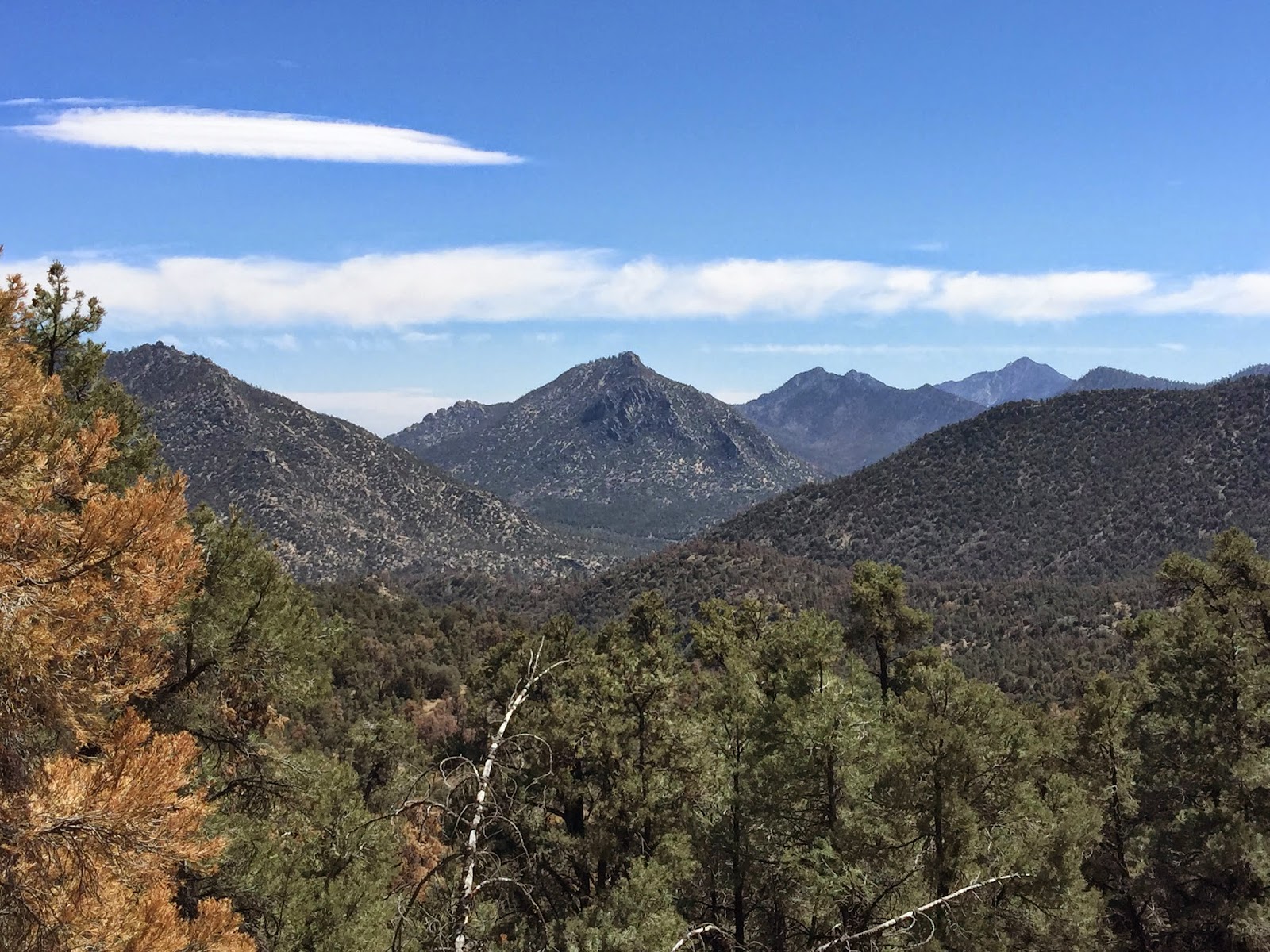
 The view back down canyon was spectacular with Haiwee Reservoir, Little Lake, the Argus Range, and Owens Lake all showing at different times along the trail.


Owens Lake

Argus Range, Southern Inyo Mts., and Haiwee Res.

Throughout the hike we recorded 58 species of birds!  We highly recommend this trail to hardy hikers who want to experience the "East Side" dramatic habitat variation and avian diversity that goes with it.


eBird Lists:
http://ebird.org/ebird/view/checklist?subID=S23079037
http://ebird.org/ebird/view/checklist?subID=S23079040
http://ebird.org/ebird/view/checklist?subID=S23079039

Track:  https://www.gaiagps.com/public/tD7WzqU7Kzw7z4zVhTL5sp18//


Friday, April 24, 2015

Mazourka Canyon

Note: I am composing this entry on my iPhone using a mobile blogging app. Hopefully it works properly...

This weekend we are in Lone Pine for the inaugural Owens Valley Bird Festival where we'll be leading field trips on Saturday. The event begins on Friday evening so we headed north in the  morning to do some hiking. The original plan was to hike to Kearsarge Pass but the weather system that's been hanging all week squashed that idea. When we got to Independence and looked up towards the Sierra crest, the clouds hung half way down the mountains and what we could see had fresh snow. 


It didn't take much thinking to change plans to the other side of the Owens Valley. Mazourka Canyon Road heads east from the south end of Independence and travels 20+ miles to the Inyo mountain crest. We only went about 5 miles and parked at the beginning of a mining road that looked good on the map. 


The road started gentle but quickly steepend so that we gained 1000 feet in the first mile.  Our first bird of the morning was a Say's Phoebe shortly after starting. Black-throated Sparrows quickly were added to the list and would be common throughout the day. About two miles (and 1700 feet elevation gain) in we connected with a more formal road and turned to the south towards a spot on the map labeled Black Eagle Mine. Two Chukar ran in front of us for a while in this stretch. There were numerous species of cactus in bloom all along the trail including several barrel cactus, claret cup, and beavertail. 


The ascent to the mine was pleasant and easy hiking on a well graded road. Rock Wrens called and sang at regular intervals. Occasional dry washes we passed by had reasonable flowers from rains earlier in the season. 


At an elevation of 7,000 feet, the Black Eagle Mine was active from 1900 to 1917 and again in 1938 pulling a variety of ores from the ground including lead,copper, silver and gold. 


A quick break for lunch and we retreated back down the road to a turnoff that would take us down  a dead end road to Willow Springs where we hoped to add a few migrant birds to the list. 


The wind had picked up substantially by this time and bird activity was minimal. We added a few species including Dusky Flycatcher, Yellow-rumped Warbler and Bewick's Wren. Our choice of route from the spring required backtracking a mile and 500 feet of elevation to the  road or cross country north through unknown country. Of course we chose cross country. After traversing several ridges and canyons we stumbled upon a wonderful historic mule trail that had to date back to the turn of the 20th century. 


Although we are certain that few hike this old trail any more it was in remarkably great shape and headed exactly the direction we needed to go. It was a fantastic end to a great day. 


This dry mountain range doesn't hold many bird species, and we only managed 15. 


The total distance for the hike was right at 12 miles with 3,300 feet of elevation gain. It was cool and breezy all day with temps ranging from 50 to the mid 60's. 


Sunday, April 12, 2015

Silver Canyon

This was an Aspendell weekend and Friday is our usual hiking day when we're here for three days. A storm earlier in the week had left a fresh layer of snow in the Sierra so hiking from home might require snowshoes as we moved higher in elevation. We've done a lot of snowshoeing this winter and with backpacking season coming soon a dirt hike sounded more appealing. This early in the season a hike in the White Mountains across the Owens Valley can be pleasant so we headed for Silver Canyon. This canyon is reached by traveling east at Laws Railroad Museum a few miles north of Bishop. The road is well graded and easily traveled in a high clearance vehicle with many shallow stream crossings to maneuver through. We drove to an elevation of 6,400 feet where Silver Canyon divides in two branches. Straight ahead the road continues all the way to the crest and intersects the Ancient Bristlecone Pine Forest road between Schulman and Patriarch Groves. Our trek would return on this road but heading up would take us in the north branch of the canyon to the historic wagon road. 
North Fork Silver Canyon


With an 8:00 AM start in a deep canyon our route would be well shaded from the sun until we climbed out of the canyon. A Spotted Towhee called near the car and a flock of over two hundred Pinyon Jays flew past us as they moved out to forage for the day. We reached the wagon road in a couple of miles and began the serious climbing out of the canyon towards the crest.  After another half a mile or so, we rounded a corner and finally reached a sunlit mountainside covered in pinyon pine. 
Claret Cup Cactus
Locoweed


Historic Wagon Road

Bird activity exceeded our expectations as we worked our way up the mountain between 8,000 and 9,500 feet elevation. It was difficult to make much progress as we continually encountered flocks of birds including many Cassin's Finches, White-breasted and Red-breasted Nuthatches, Mountain Chickadees, and Clark's Nutcrackers. The real surprise was two Lewis's Woodpeckers and three flocks of Evening Grosbeaks totaling at least 45 individuals.

Sierra Crest Across Owens Valley
 The higher we climbed the more the view of the Owens Valley and the snow capped Sierra opened up. The pinyons  gave way to higher elevation species like Mountain Mahogany and Mountain Juniper. 

Old Mining Cabin
At 9,800 feet we stopped for lunch at the historic cabin prior to our final ascent to the crest. Foxtail Pines dotted the landscape at this elevation. Continuing up we reached a fine stand of Bristlecone Pines at 10,000 feet where a Sooty Grouse called nearby and several Red Crossbills flew over.  

Bristlecone and Foxtail Pines
Once through this grove we entered the high alpine habitat typical of the crest with stunted sagebrush and wide open vistas. Numerous Mountain Bluebirds greeted us at the top along with a singing Horned Lark. 
Bridge


White Mountains Crest with Blanco Mountain Beyond

We traversed the crest at an elevation of 10,500 feet, 7.5 miles from the start, connecting with the Silver Canyon jeep road for our descent back to the car. A short distance down the road we ran into a flock of Red Crossbills feeding in a stand of pines at eye level and only yards away. It would have been easy to spend an hour watching these cone specialists work their magic but the quad busting downhill awaited. We dropped 4,000 feet in 5 quick but punishing miles and reached the car in the early afternoon. 


Steep Downhill on Jeep Road


The weather was pleasant all day, starting out in the high 30's in the morning, 50's at the crest with a moderate wind at times, and in the high 60's at the end. 

Bird List: http://ebird.org/ebird/view/checklist?subID=S22840431

GPS track: https://www.gaiagps.com/public/ArqwOhrNjDNix3FJt5QD6JqJ//


Sunday, April 5, 2015

One year and counting...

Sierra Crest looking south.  Owens Peak is on the right side of
the horizon.
One year from now, Susan and I will start the Pacific Crest Trail - thru hiking from Mexico to Canada.  It was appropriate that yesterday we hiked a section of the trail from Chimney Creek campground (mile 680) to the ridge (mile 687) overlooking the Domelands Wilderness.

Domeland Wilderness

This section of the trail is only about 45 minutes drive from our house in Inyokern and it's too bad we had never hiked it before - it was excellent! Starting at an elevation of 5500 feet in a mixed Pinyon and Gray Pine forest, we ascended gradually to 8000 feet at the ridge.  The final couple of miles passed through an old burn that was slowly recovering and had some sporadic low level habitat.

The trail continues beyond where we stopped into Rockhouse Basin at the edge of the Domeland Wilderness.  From there it parallels the South Fork of the Kern River to Kennedy Meadows at Mile 702.  Kennedy Meadows is the last stop in civilization before entering the High Sierra Nevada and many miles of wilderness.

This section of trail passes the old Fox Mill mining site with a spring close by. Water was burbling out of the spring below the willows, but the pipe into the trough was barely a trickle.


Fox Mill Site


Fox Mill Spring 
Horse trough at spring


Trail Flowers
Phlox
Flowers along the trail were decent at times, with some coreopsis, blue dicks, evening snow and others down low, and phlox up high.  

Of course we never go in the mountains without looking for birds and this trip didn't disappoint. Soon after leaving the car a Brown Creeper was seen foraging in the mixed pinyon and gray pines.  While there we heard a flycatcher singing.  The only flycatcher that breeds in this habitat is Gray, and while the song was a dead ringer, it wasn't until later in the day that Susan got one in view to confirm. Based on location and song, we had at least two males on territory in a mile plus stretch of trail. The date seems a little early for Gray Flycatcher, but with the mild winters these days, who knows...  We also had another pinyon forest specialist, a singing Black-throated Gray Warbler clearly on territory already.  Some other birds of interest in the pine forest were Mountain Chickadee, Oak Titmouse, Pacific White-breasted Nuthatch, and Lawrences Goldfinch. Both Western and Mountain Bluebirds were seen in the burn area above 7000 feet elevation along with Blue-gray Gnatcatcher and Hairy Woodpecker.  In all we had 27 species which is pretty good for the habitat and early date.  Our total bird list for those interested: http://ebird.org/ebird/view/checklist?subID=S22700181

We chose this hike to avoid the high winds forecast in other parts of the mountains and it worked out well for us.  It was calm all morning, the wind picking up to a still tolerable level in the early afternoon.