Day 1
 |
| Horseshoe Meadow |
With six days of food on board
we headed out with only one goal in mind - visit the Miter Basin south of Mt
Whitney and west of Mt Langley. Friend Rosie told us this off trail location is
one not to miss.
There are a few ways to get in
the basin and we chose Horseshoe Meadow to Cottonwood Pass, a few miles of our
beloved PCT, then up the Rock Creek trail. The day was glorious with hardly a
cloud to be found and no smoke from any fire!
As we entered the Basin, Susan
had an idea we both quickly agreed to. With the perfect weather for the next
couple days, why not bag Mt Langley while we are in the neighborhood. We
trudged the last steep mile to upper Soldier Lake to position ourselves for the
morning ascent. It's still 3000 feet higher and a couple of cross country miles
but that's for tomorrow.
 |
| Chicken Springs Lake |
 |
| Big Whitney Meadow |
 |
| Siberian Outpost, Grunion Plateau, Great Western Divide |
 |
Bambi's dad
 |
 |
| Lower Soldier Lake |
 |
Lower Soldier Lake, Joe Devel Peak
 |
| Upper Soldier Lake |
|
 |
| Camp at Upper Soldier Lake |
Day 2
 A relatively early start saw us
moving toward the head of the Soldier Lakes valley and the steep head wall that
pointed toward the use trail to the top of Mt Langley. Susan had spied a faint
trail up the wall the night before and we found it quickly. This route to the
top gets some use so we weren't surprised to find a trail. And it was a good
one, weaving in switchbacks both easy and steep to the ridge a thousand feet
above.
A relatively early start saw us
moving toward the head of the Soldier Lakes valley and the steep head wall that
pointed toward the use trail to the top of Mt Langley. Susan had spied a faint
trail up the wall the night before and we found it quickly. This route to the
top gets some use so we weren't surprised to find a trail. And it was a good
one, weaving in switchbacks both easy and steep to the ridge a thousand feet
above.
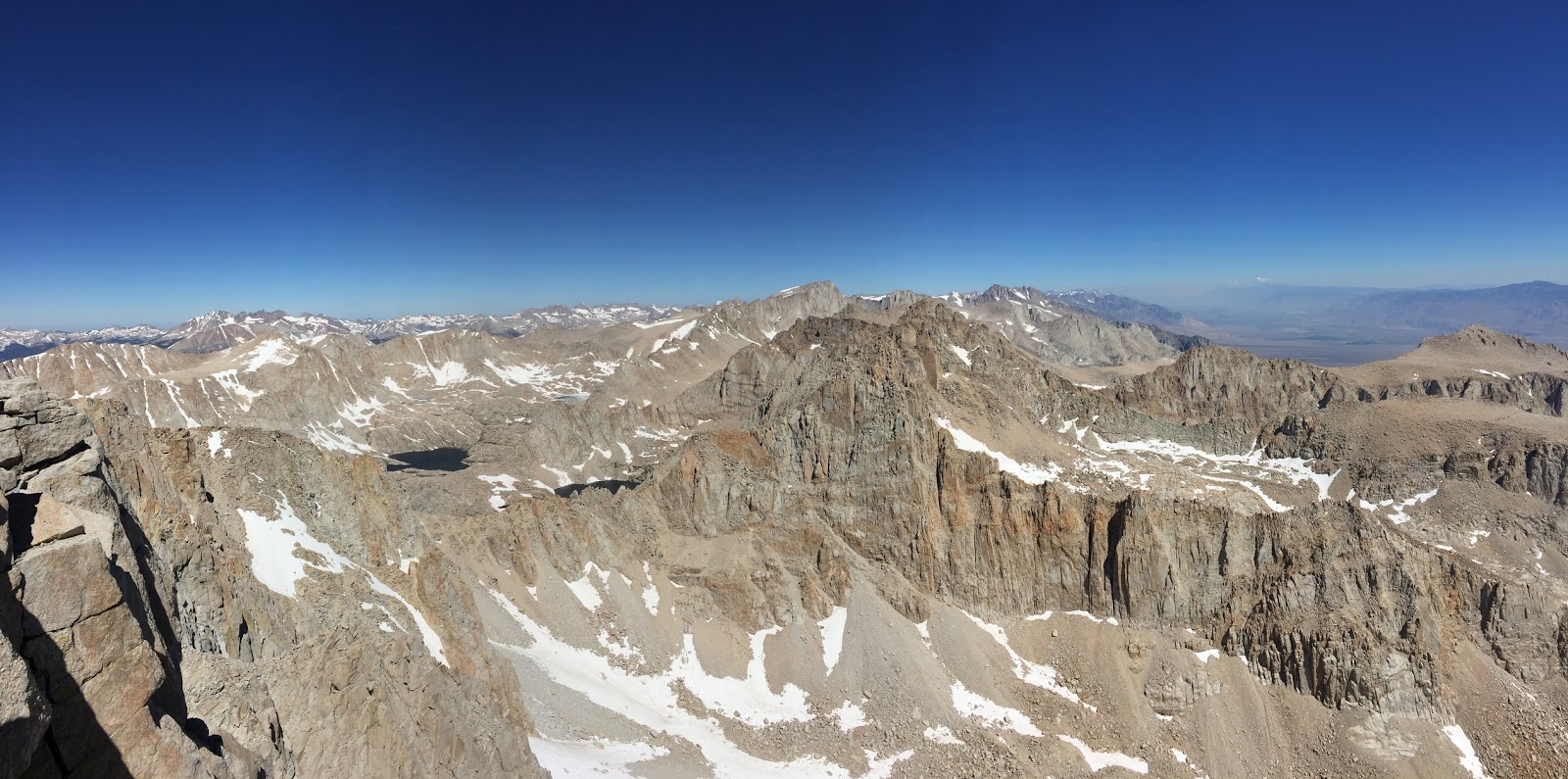
Once on top we followed the well worn trail toward the summit. Little snow remains now and the going was good - although we could have used a bit more oxygen as we moved through 13,000 feet. Giant cairns marked the way to nearly the top which helped when the trail became more obscure.
And then we were there, perched on top of the world at just over 14,000 feet. The view in every direction was spectacular. Mt Whitney, only a few hundred feet higher dominated the view north. The Kawea group and Great Western Divide traversed our view to the west. To the east was the Owens Valley and Owens Lake ten thousand feet below. And to the south the lower reaches of the southern Sierra with Olancha and Kern Peaks most prominent. We could even see Owens Peak over 50 miles to the south and knew it stood proudly over our own Indian Wells Valley.
We lingered for a while at the top soaking in the views. The descent was quick if quad punishing, retracing our track to camp at upper Soldier Lake. Just as we reached the valley floor we heard the distinctive call of a Chukar. But here? Finally Susan got a look at him perched on a rock above and cackling his heart out. A Chukar at 11,500 feet elevation - amazing.
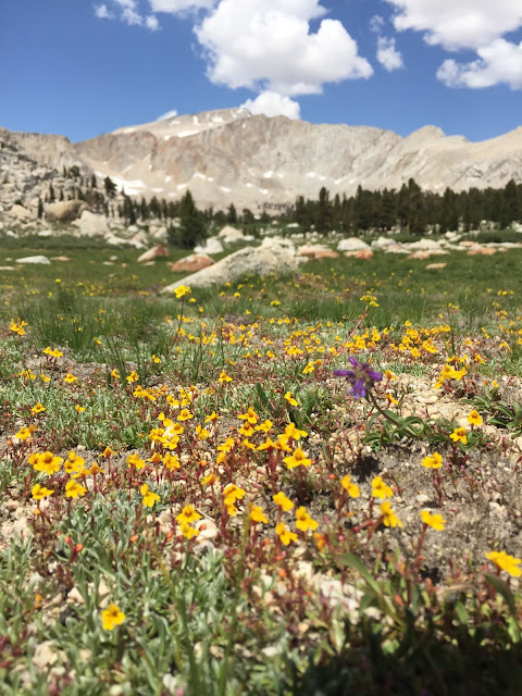
And the flower of the day was Sky Pilot, one of my favorites. This polemonium only grows at the highest elevations and is always a treat to see.
 |
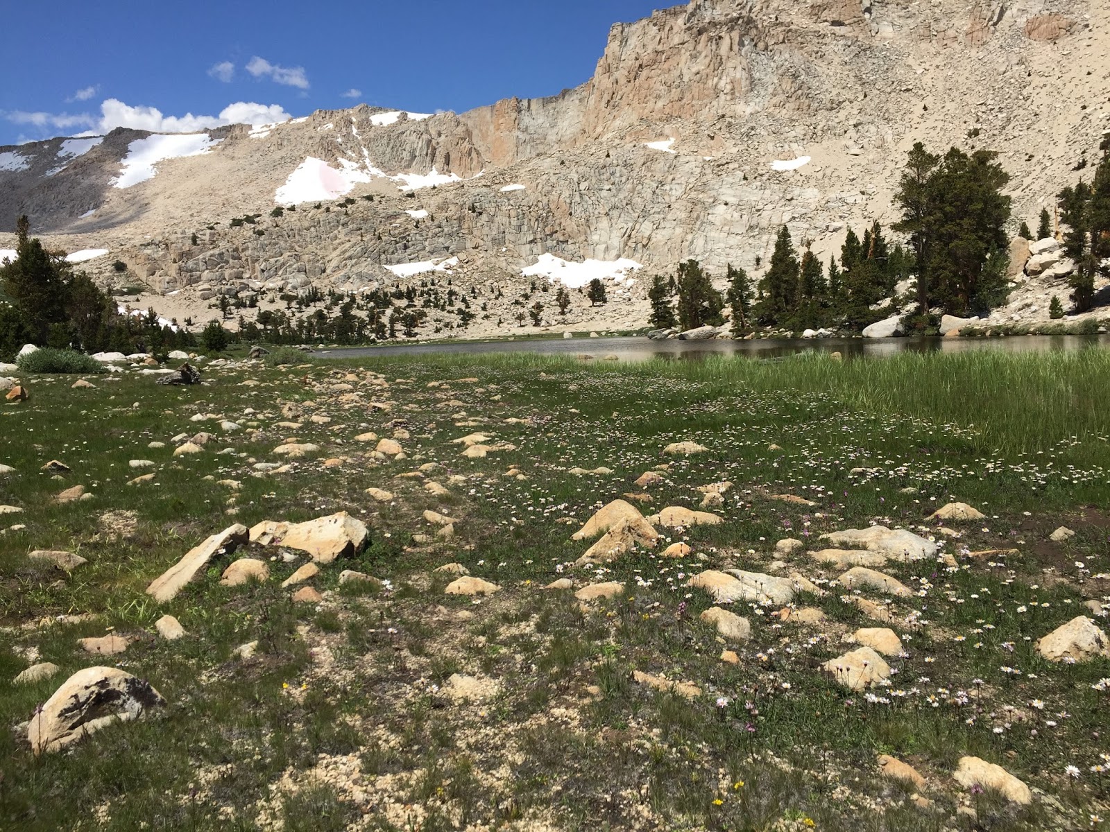
Soldier Lakes basin
 |
 |
| The route is marked by park service constructed giant cairns to help minimize the number of informal routes and habitat damage |
 |
| Soldier Lakes, Siberian Outpost, Boreal Plateau, Great Western Divide to the west |
 |
| My favorite alpine flower, Sky Pilot (Polemonium eximium), found only at the highest elevations |
 |
Cottonwood Lakes basin from near the summit
 |
| Alpine Gold, another high elevation flower |
|
 |
| Hiking the last few meters to the top |
 |
| The view northeast from the summit |
 |
| Looking north and northwest from the summit. Our destination for the rest of the trip, the Miter Basin, holds the lakes left of center |
 |
| Among the summit blocks |
 |
| East to Tuttle Creek and Lone Pine (10,000 feet below) |
 |
| Almost back to camp |
Day 3
 Not far but spectacular. After
our ascent yesterday of Mt Langley it was time to explore the Miter Basin
proper. Instead of dropping all the way down to Rock Creek from our lofty perch
at upper Soldier Lake we picked our way across the divide on a series of
granite and grassy ramps. We were able to stay high on the canyon side and make
our way up to the side drainage that holds Iridescent Lake, our goal for the day.
Not far but spectacular. After
our ascent yesterday of Mt Langley it was time to explore the Miter Basin
proper. Instead of dropping all the way down to Rock Creek from our lofty perch
at upper Soldier Lake we picked our way across the divide on a series of
granite and grassy ramps. We were able to stay high on the canyon side and make
our way up to the side drainage that holds Iridescent Lake, our goal for the day.
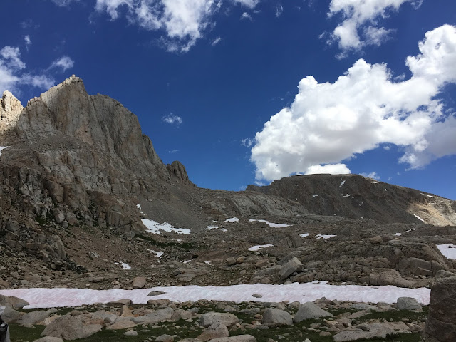
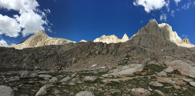
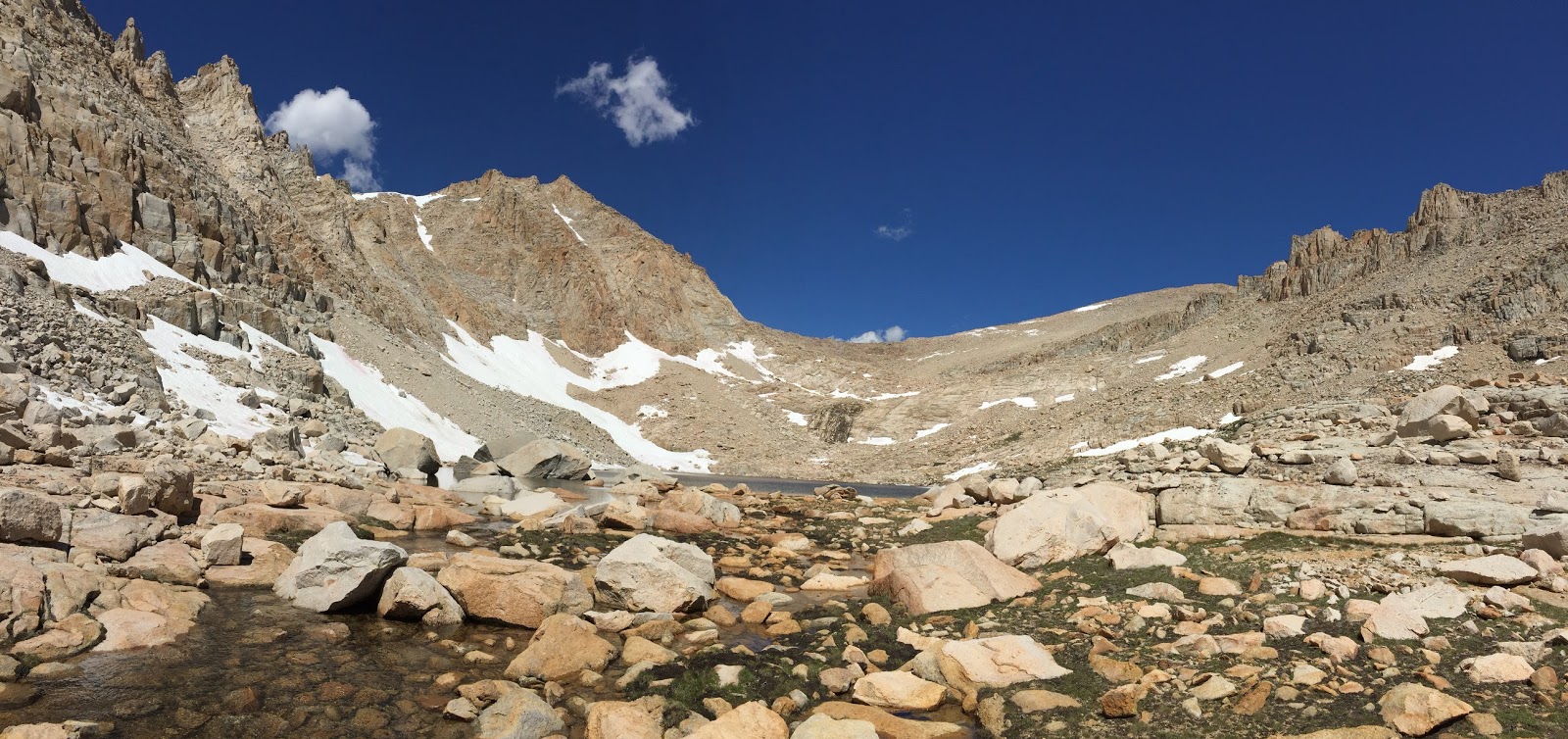
From there it was an easy climb
up to the lake with several majestic peaks to lead us on. The Miter, Mt
Corcoran, and Mt LeConte form the backdrop to this gorgeous alpine lake.
As this trip is mostly about scenery and not miles we found a campsite and
threw down the packs. Each of us took turns climbing to the divide on the west
side and overlooking Sky Blue Lake. That is tomorrow's destination.
 |
| Into the Miter Basin |
 |
Bob getting a close up panorama flower photo (below)
 |
 |
The Miter is on the right


|
 |
| The Miter |
 |
| Iridescent Lake |
 |
| The Miter |
 |
| Sky Blue Lake from the divide |
 |
| Sunset at Iridescent Lake |
 |
| Sunset alpenglow |
Day 4
 We moved camp today from
Iridescent Lake to the nearly comparable Sky Blue Lake in the main Miter Basin.
With no plans to continue any farther up canyon for camping we dropped our
packs and set up camp. With nothing in our packs but lunch and a few spare
clothes we set off to explore the upper basin.
We moved camp today from
Iridescent Lake to the nearly comparable Sky Blue Lake in the main Miter Basin.
With no plans to continue any farther up canyon for camping we dropped our
packs and set up camp. With nothing in our packs but lunch and a few spare
clothes we set off to explore the upper basin.
Contouring around the lake we
picked a line to gain elevation and avoid the incredibly steep granite. With a
bit of weaving here and there we managed to see all the unnamed ponds and lakes
all the way to the base of the final climb to Crabtree Pass. We lunched at the
big lake below the pass. This is some pretty spectacular country and we were
happy to finally see it.
A special treat on our way back
was spawning Golden Trout in the inlet stream just above Sky Blue Lake. There
were dozens of fish and some really big ones. Very cool!
Day 5
 |
| Crossing the Sky Blue Lake outlet stream |
Another day where camp only
moved a couple miles as we continue our exploration of the Miter Basin. We
descended from Sky Blue Lake far enough to get a good angle to the approach to
Primrose Lake. The ascent was easy on ramps in the granite. Once there we were
convinced this would be our final campsite as the view in this glacial carved
bowl was outstanding. Up went the tent so we could shed ourselves of excess
weight before a day hike to the next side valley down - Erin Lake.
Looking at the map we suspected
this would be a tough one and we weren't disappointed. Dropping a few hundred
feet from Primrose we found a reasonable bench to traverse. The final climb
up to Erin Lake was exciting as it demanded some serious route finding and class
3 scrambling. Our resident acrophobe was not happy but she braved the climb
(and even scarier descent). We had lunch at Erin which was pretty enough but
not as good as the other lakes we visited on the trip. Camping tonight at
Primrose was the right call.
Tomorrow will be a long day as
we have to get out of the Miter Basin, climb up and over New Army Pass, then
knock out the miles back to the trailhead. Camping one more night in the Miter
will make it worth the effort.
As I write this the thunder
boomers are building again. We'll see...
Day 6
 |
| Sunrise at Primrose Lake |
Today was get out day, as all good things must end. Besides, we were about out of food... We found ourselves a good long way from the car so were up and at it early. Dropping down from Primrose lake we picked up a faint use trail that appeared to be the typical route into the basin for those headed to Sky Blue Lake and beyond. We followed it, and Rock Creek, down to a wet meadow (look out, skeeters!!) then contoured over to the New Army Pass connector trail. Another mile or so and we were on the main trail to the pass and headed up, way up. New Army Pass sits at 12,300 feet elevation, some rarefied air indeed. It took us a while to get there so we were ready for lunch. Tucked out of the wind we enjoyed our last looks for this trip of Mt. Langley, the Whitney group, Kaweahs, and Great Western Divide.
Then it was down into the Cottonwood Lakes basin and back in the trees. Some more miles on a familiar trail and we were back to the trailhead. This is a beautiful stretch but does get quite a bit of backpacker and hiker pressure.


 A relatively early start saw us
moving toward the head of the Soldier Lakes valley and the steep head wall that
pointed toward the use trail to the top of Mt Langley. Susan had spied a faint
trail up the wall the night before and we found it quickly. This route to the
top gets some use so we weren't surprised to find a trail. And it was a good
one, weaving in switchbacks both easy and steep to the ridge a thousand feet
above.
A relatively early start saw us
moving toward the head of the Soldier Lakes valley and the steep head wall that
pointed toward the use trail to the top of Mt Langley. Susan had spied a faint
trail up the wall the night before and we found it quickly. This route to the
top gets some use so we weren't surprised to find a trail. And it was a good
one, weaving in switchbacks both easy and steep to the ridge a thousand feet
above. 


 Not far but spectacular. After
our ascent yesterday of Mt Langley it was time to explore the Miter Basin
proper. Instead of dropping all the way down to Rock Creek from our lofty perch
at upper Soldier Lake we picked our way across the divide on a series of
granite and grassy ramps. We were able to stay high on the canyon side and make
our way up to the side drainage that holds Iridescent Lake, our goal for the day.
Not far but spectacular. After
our ascent yesterday of Mt Langley it was time to explore the Miter Basin
proper. Instead of dropping all the way down to Rock Creek from our lofty perch
at upper Soldier Lake we picked our way across the divide on a series of
granite and grassy ramps. We were able to stay high on the canyon side and make
our way up to the side drainage that holds Iridescent Lake, our goal for the day. 


 We moved camp today from
Iridescent Lake to the nearly comparable Sky Blue Lake in the main Miter Basin.
With no plans to continue any farther up canyon for camping we dropped our
packs and set up camp. With nothing in our packs but lunch and a few spare
clothes we set off to explore the upper basin.
We moved camp today from
Iridescent Lake to the nearly comparable Sky Blue Lake in the main Miter Basin.
With no plans to continue any farther up canyon for camping we dropped our
packs and set up camp. With nothing in our packs but lunch and a few spare
clothes we set off to explore the upper basin. 


Beautiful area & photos.
ReplyDeleteWowsers!! I really have enjoyed seeing this back country. My kind of rugged punctuated with stunning wildflowers and reflective lakes. I so much appreciate your sharing, including photos of you both.
ReplyDelete