Some hikers are "peak baggers," and while we've bagged our share of peaks, Susan likes to consider herself a "lake bagger." If there's a lake anywhere we are hiking, she needs to see it. So when we decided to do a backpacking trip to the Ritter Range (including the Minarets), maximizing the number of lakes we tagged was required. Some of this hike would be on trail and some cross-country. And we would pick up a few more of the few remaining miles of the Sierra High Route that we had yet to accomplish.
The Ritter Range is a roof pendant of metamorphic rock that pre-dates the plutonic granitic intrusion that forms the majority of the younger Sierra Nevada Mountains. It sits "on top" of the younger mountains with a totally different geology. Roof pendants exist all throughout the Sierra Nevada but the Ritter Range and Minarets are among the most scenic and well known. This sub-range of the Sierra Nevada is located west of the town of Mammoth Lakes with several trailheads that lead out from near Devils Postpile National Monument. Construction on the road to Devils Postpile limits accessibility for the summers of 2024 and 2025 to just weekends. But that also means fewer visitors in the backcountry and a more enjoyable experience for us. But considering the obscure routes we take, we don't see a lot of folks anyway.
Day 1 (7 miles, 2,500 feet elevation gain). This wasn't a trip for big miles, but for wandering and seeing amazing beauty of this area. We started out at Devils Postpile NM and took the King Creek Trail toward the southern end of the range. The Monument is at relatively low elevation so we would be climbing most of the day. By late afternoon we were well into the higher elevations at the base of the rugged mountains and Ashley Lake.
Middle Fork San Joaquin River as it passes through Devils Postpile NM
While we didn't take the time to walk over to the Postpile, we did get a great look from the trail
Beginning the hike on the King Creek Trail
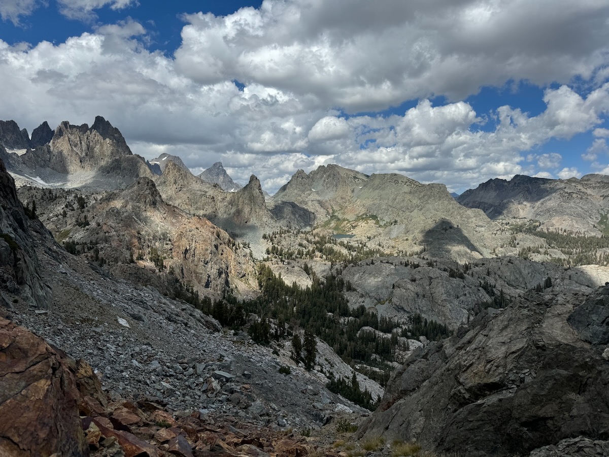
Our first views of the Minarets in the distance
Fern Lake
Anona Lake
Crossing the ridge to Ashley Lake
Ashley Lake as we pull in for the evening
Day 2 (5.5 miles, 1,700 feet elevation gain). This was a day for maximum wandering, cross-country passes, and crazy weather. It started out lovely for the morning as we poked our way from lake to lake - from Ashley we hit Noname, Holcomb, and Lower Beck before stopping for lunch and sorting our approach to Nancy Pass on the Sierra High Route. There is debate over which "notch" on the ridge is Nancy Pass. But at this location I still had cell phone reception so did more research while studying the ridge in person. I found a photo from one of the original party members who placed the commemorative plaque at the pass which made it pretty obvious where we needed to go. The map showed the pass about 1/4 mile east in a different notch in the ridge. We decided to trust the first person account and headed up. Sure enough, we found the memorial. After crossing the pass and carefully picking our way down the north side, we traversed to the much easier Deadhorse Pass and on to the lake. By this time the wind was howling and the temperature had dropped to unpleasant range. It was difficult to find a protected campsite, but we were lucky to tuck into the only grove of trees at this alpine lake. Up went the shelter, dinner was gobbled down, and we hid for the rest of the evening.
Ashley Lake in lovey morning light
Ashley Lake, Iron Mountain dominates the skyline
Continuing along we encounter Noname Lake (that's its official name on the map)
Noname Lake
Holcomb Lake
Lower Beck Lake
Nancy Pass on the Sierra High Route
View south as we approach the pass
Nancy Pass on the ridge that divides the Beck and Deadhorse Lakes drainages. Young Nancy was the first in her party to make this cross-country pass in 1967 at the tender age of 8. She died of acute Leukemia two years later. Her family dedicated this plaque to her in 1971 and the name stuck.
Looking north from the pass into the Minarets
The descent from the pass was steep and tedious
While picking our way down from the pass, it was tough not to constantly stop and admire the views
Some parts may have required more than the normal two feet drive
We pull in to Deadhorse Lake on a miserable late afternoon
Thankfully we found a protected site
I did have to jump out of the tent for a few minutes at sunset
Day 3 (3.4 miles, 650 feet elevation gain). Minarets day. From Deadhorse lake we would spend the day passing below the Minarets, the iconic jagged peak group in the Ritter Range. While most of the hiking wasn't terribly difficult, the views had us pausing so regularly that we hardly went anywhere all day. Well, isn't that why we're there? We think so. From Deadhorse we took a cross-country approach to Minaret Lake then climbed the ridge above the lake to reach Cecile Lake. After considerable boulder hopping we were around the lake and looking down the nasty descent to Iceberg Lake. This short section of steep "trail" is infamous in Sierra hiking. It is steep, loose, and covered with a high angle snowfield for much of the summer in typical years. In each of the last two summers, a hiker has fallen to their death on this section of trail by not being prepared for high angle snow/ice hiking. For us, this late in the year, it was just another section of steep snow-free trail that required careful attention. No big deal.
Once at Iceberg Lake we looked at our options and decided to have an early day in camp. We descended a short distance down from the lake and found a bench along the creek with amazing views and good protection from the stiff wind that had come up again in the afternoon.
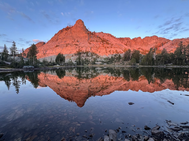
Deadhorse Lake in morning light, and much more pleasant weather. The mountain right of center is Starr Minaret.
Starr Minaret above Deadhorse Lake
Moving cross country toward Minaret Lake
Some scrambling required
Minaret Lake
Minaret Lake
Minaret Lake
Minaret Lake
Just over the crest is Cecile Lake
Cecile Lake
Starting the descent to Iceberg Lake
Iceberg Lake
Very steep and tedious
Iceberg Lake looking back at the slope we descended
Not far from the outlet of Cecile Lake we found a nice site with wind protection
The view from camp, our first good looks at Mt. Ritter and Banner Peak
Day 4 (2.2 miles, 850 feet elevation gain). We didn't go far today, but boy did we get the views. On this day we were headed right for Mt. Ritter and Banner Peak, and would camp immediately below in maybe our most favorite spot in the Sierra, Nydiver Lakes (we've been here many times on day hikes). We left camp and continued the descent to near Lake Ediza before turning up toward the peaks. At the base of the snowfields on the lower flank of Mt. Ritter we stopped for a very long lunch with a family group of four American Dippers. These guys were highly entertaining with their amazing antics and we enjoyed watching them immensely. They were so confiding with us that I was able to get some pretty cool video footage with just my phone. If you watch the video through to the end, I added some neat slow motion footage.
After lunch we made the relatively short ascent to the Nydiver Lake plateau, found a lovely campsite with incredible views of the peaks, and lounged around all afternoon soaking it all in. Backpacking doesn't get better than this.
Mt Ritter and Banner Peak in morning light
Looking back at the Minarets as we move on
Ritter and Banner and the creek that comes from them
This lovely waterfall is still going well even late in the season
Mt. Ritter (L) and Banner Peak
An ice water foot soak!
American Dippers forage along the stream
Since the dipper video won't embed in the email version of this post, click here to view. Don't miss this one!!
Not a bad campsite view from Upper Nydiver Lake
Middle Nydiver Lake view from near camp
Day 5 (7 miles, 1,300 feet elevation gain). We struggled to get out of camp this morning as we were continuously captivated by the views. But after spending four days traveling north, and only two days of food remaining in our packs, south we must go - and pick up the pace a bit. We traversed the Nydiver plateau visiting all the lakes soaking in the scenery. With a tricky little cross-country descent we were back on the formal Shadow Creek trail. We traveled east on this trail for a while before connecting to the John Muir Trail (JMT) near Shadow Lake. Turning south we hike past several lakes but didn't want to camp on the JMT freeway. With a bit of cross-country route finding we picked a shortcut to Emily and Castle Lakes. While Emily was nice, Castle Lake had a great view and turned out to be a fantastic last night of camping. We even had a pair of bachelor Mule Deer who thought browsing right through our camp was the thing to do. Too cool.
Ritter and Banner in lovely morning light
One of us couldn't get enough of this view. It took a while to get out of camp
.
Upper Nydiver Lake reflection
Middle Nydiver Lake
The Minarets from near Lower Nydiver
Ediza Lake is below. Cecile and Iceberg Lakes are in that notch across the way.
One more look back from Lower Nydiver Lake
A tricky descent from Nydiver Lakes back to a real trail
You'd never know by looking that this is passable, but we made it down from the top
This area was prospected for minerals many years ago
We even found an old cabin site not far from the mine diggings
Shadow Creek as we hike the trail
The JMT bridge across Shadow Creek
Shadow Lake
Rosalie Lake along the JMT
Gladys Lake on the JMT
Now off the JMT, this is Emily Lake
Castle Lake
Notice that we did NOT pitch our tent (on the left) under this tree that looked like it could fall at any minute. It will probably be there for another hundred years...
From a ridge near camp we had an incredible view to the south. Mammoth Ski Mountain is on the left.
A gorgeous pair of bachelor bucks walked right into our camp. Neither could care less that we were there as long as we moved slowly.
This dude was a beast!
Day 6 (6.2 miles, all down hill). Go home day. Leaving camp there was an old trail south that sees little use, and no maintenance, for a couple of miles back to the JMT. From there it was a quick four miles down to Devils Postpile and civilization.
The "Castle" above Castle Lake in early morning light
Heading out in the morning of our last day
Looking back toward Castle Lake in the notch
One last look at the Minarets as we close out our trip
As for the birds, Goshawk, Black-backed Woodpecker, Pine Grosbeaks, and more! eBird Trip Report